


Hurricane Beryl caused devastating damage in parts of the Caribbean, putting a spotlight on the role of climate change.
With maximum sustained winds exceeding 160 mph (257 km/h), it was the first Category 5 hurricane in the Atlantic in nearly 100 years.
In fact, only one Category 5 Atlantic hurricane has ever been recorded in July, Hurricane Emily on July 16, 2005.
The causes of individual storms are complex, making it difficult to definitively attribute specific instances to climate change.
However, the main reason for Hurricane Beryl’s intensity was unusually high sea surface temperatures.
Typically, such strong storms only occur later in the season, when the ocean has warmed over the summer.
For a hurricane to be possible, the ocean surface must be at least 27°C warmer. As the map below shows, the waters along the path of Hurricane Beryl were exceptionally warm for this early in the season.
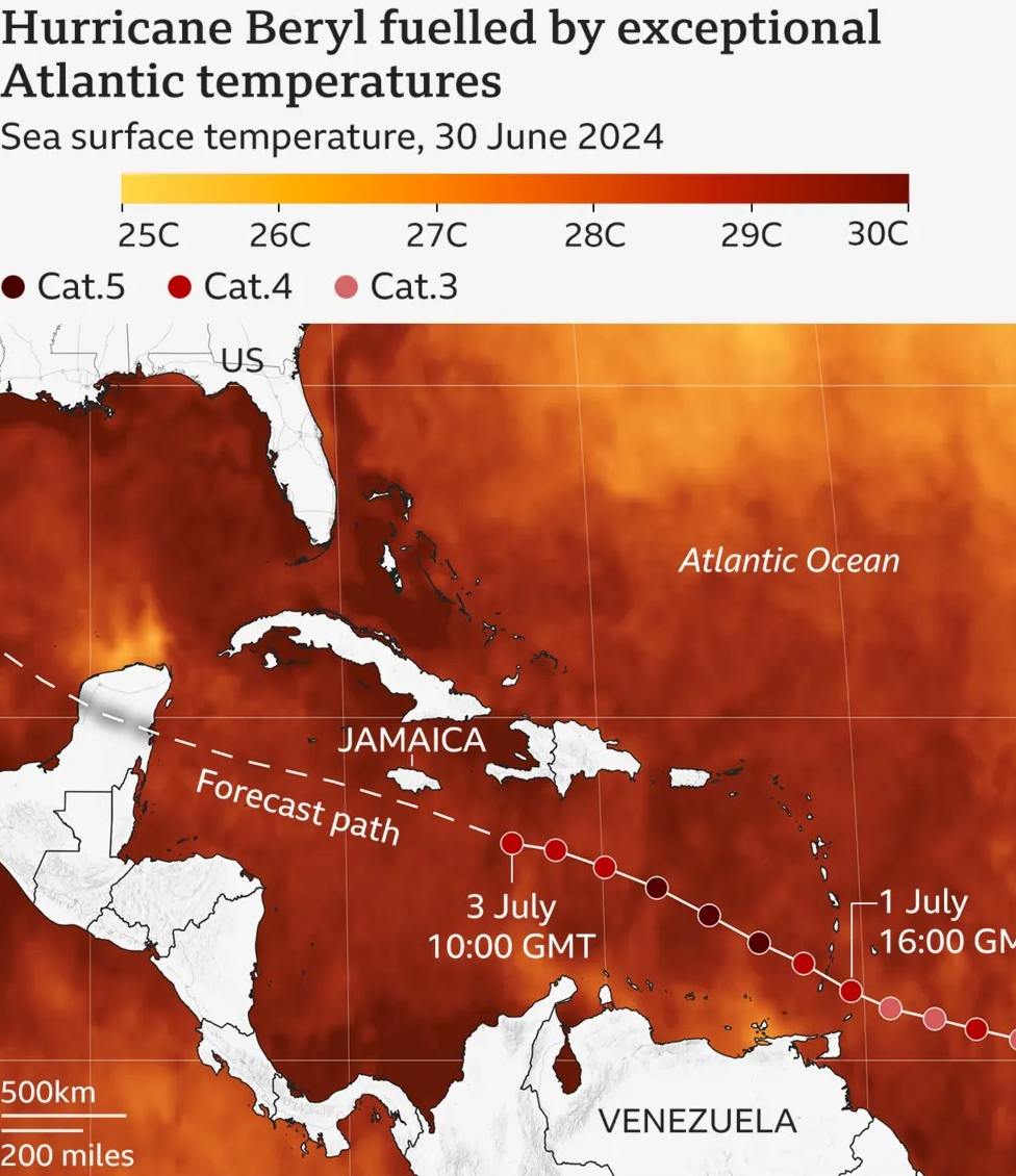
All else remaining constant, the warmer the ocean, the more powerful hurricanes are likely to form because storms can absorb more energy, which can result in higher wind speeds.
We know that as the planet warms, the temperature of the ocean surface also increases,” explains Andra Garner, assistant professor at Rowan University in the US.
“And we know that these warm oceans are a significant fuel source for hurricanes.”
In the main Atlantic hurricane development region, ocean heat content, the energy stored throughout the water column, is reaching levels that it doesn’t normally reach until September.
Because the ocean surface is usually warmest in late summer, this is when the Atlantic hurricane season is at its most active.
This is shown in the following chart, where the dots represent major hurricanes from 1940 to 2024. As you can see, most major hurricanes occur in late August and September, and hurricanes before that are very rare.
While it’s unheard of for a Category 5 hurricane to occur so early in the season, its intensity fits into the bigger picture of how these storms are changing in a warming world.
The number of hurricanes has not increased, but as temperatures rise, a greater percentage of hurricanes are expected to reach the highest category.
“It is not clear to what extent climate change contributed to the initial formation of Hurricane Beryl, but our climate models suggest that the average intensity of hurricanes will increase in the future due to ongoing global warming,” explains Hiroyuki Murakami, a scientist at NOAA’s Geophysical Fluid Dynamics Laboratory.
Another factor to consider this year is regional weather patterns.
The El Niño phenomenon recently ended in the eastern Pacific.
Because El Niño affects winds in the atmosphere, it suppresses the development of strong hurricanes in the Atlantic. The opposite phenomenon, known as La Niña, promotes hurricane development in the Atlantic.
Currently, “neutral” conditions prevail, where neither El Niño nor La Niña occurs. However, a La Niña event is expected to develop later this year.
This likely change, along with warmer ocean temperatures in July and August, has raised concerns that even more powerful hurricanes may develop later in the season.
“Hurricane Beryl has set a precedent for what we fear will be a very active and very dangerous hurricane season that will impact the entire Atlantic basin,” said Cor Barrett, deputy secretary-general of the World Meteorological Organization.
The National Weather Service’s Noah warned in May that an “unusual” Atlantic hurricane season was on the way, predicting four to seven major hurricanes of Category 3 or higher (winds of 178 kilometers per hour or more) between June and November. On average, the Atlantic gets hit by three major hurricanes each year.
Rapid Intensification
Meteorologists and climate researchers have also noted how quickly Hurricane Beryl is intensifying.
It took just 42 hours for a tropical cyclone with maximum sustained winds of 38 mph or less to become a major hurricane .
“Beryl is particularly noteworthy because it intensified most rapidly from tropical cyclone to hurricane […] [among all Atlantic hurricanes that occurred in June or early July],” explains Shuyi Chen, professor of atmospheric sciences at the University of Washington.
Hurricane Beryl is an example of “rapid intensification,” where maximum wind speeds increase very quickly.
This can be particularly dangerous because communities have little time to prepare. The frequency and magnitude of these rapid intensification events in the Atlantic seem to have increased in recent decades.
“As unprecedented as Beryl is, it’s very similar to the types of extreme events we would expect in a warmer climate,” says Dr. Garner.
“Warming the planet essentially increases the likelihood of extreme events to ourselves, making events like Hurricane Beryl not only more likely, but more likely too.”